|
Bucks Geology GroupBuckingham Sand Pit
Grid reference: SP 700 344.Ordnance Survey map: Aylesbury and Leighton Buzzard Sheet 165.Geological maps: 1:50,000 series Buckingham sheet 219.Bucks County Council administration area: Aylesbury Vale District Council.Owned by: The site is maintained by Aylesbury Vale District Council, Haydon Mill, Rabans Lane , Aylesbury, Bucks, HP19 3ST.Area of site: 1.8 ha.
Access, location and parking: At present this site is accessible for visits by permission only and hence it would be best visited on Open Days or with a group, such as local geological societies (e.g. BGG or the Open University Geological Society). This site could be visited together with Buckingham Town Centre with its Old Gaol Museum (including local geology exhibit) and Coombs Quarry.The site is surrounded by a high fence and padlocked gates for safety reasons. The site is a disused sand pit, now a nature reserve, in a residential area. There is parking in town centre a short distance away from the site.
Interest Summary: This is one of the few permanent exposures of Quaternary sediments in the county which gives direct evidence for several environments of the Ice Age: an ice sheet, outwash sands from a melting glacier and tundra conditions.
Buckingham Sand Pit - Geology NotesThe sand pit at Buckingham preserves an opportunity to see some rare Ice Age geology in England. The clays, sands and pebble layers within the pit are the only direct evidence we have that we were once in the grip of moving ice - under an ice sheet that measured about 2 kilometres thick. After that time, Buckingham was in the path of melt waters from the receding ice, which was subsequently followed by the intense cold of a tundra environment. The ice sheet covered Buckingham some 450,000 years ago, there were two further ice advances after this time, and the last cold chills from the tundra winds ended only 10,000 years ago. We are presently experiencing a nice warm interglacial period - but beware - we are still within the 'Ice Age' and the ice will be back!
Ice ages - what causes them?The last Ice Age was within a period of time known as the Quaternary which started just under 2 million years ago. However, this was not the only 'Ice Age' to affect the Earth. By looking at the geology of countries around the world it is now known that there have been several ice ages throughout Earth history, and some of these may have been responsible for mass extinctions of life extinguishing as much as 80% of all living species in a single go! The main ice ages are known to include:
The last Ice Age is well known in Britain, mostly from the erosional valleys and other features in Scotland, the Lake District and Wales, but it is also seen as the glacial sediments of Norfolk and other Counties. It is a real treasure to have evidence still visible in southern England.The causes of ice ages is still one of hot debate amongst geologists (excuse the pun!) Some recent theories include:
Buckingham Sand Pit - what you can see
Whatever the cause of ice ages, the effects are clear to see - changes in world climate, sea-level changes as ice sheets melt (giving a sea-level rise) and as ice sheets grow (a sea-level fall). With these climatic changes habitats change from the non-vegetated ice sheet to tundra to grassland to woodland. In this quarry we have good evidence for one environment the ice sheet of the Anglian period of half a million years ago and subtle evidence of another associated environment, a tundra.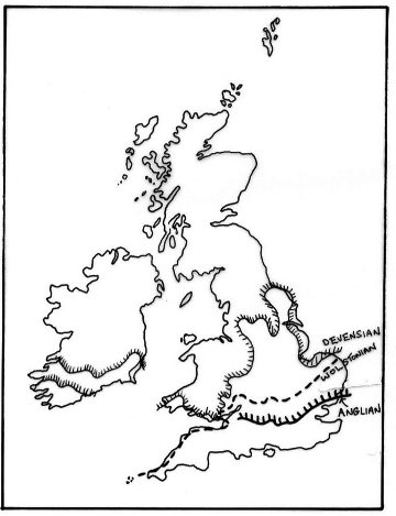
The three main ice fronts that have left good evidence: the Anglian, the Wolstonian and the Devensian. The oldest is the Anglian (half a million years) and the youngest is the Devensian, ending just 10,000 years ago.The evidence for the ice sheet, and for melting at the base of the ice, is seen in the pebbly clays near the west entrance and the adjacent loose pebbly sands. The tundra environment is more subtle, but the small clues can be found if you are keen to look in a true Sherlock Holmes fashion! This evidence is in the form of fragments of plant material within the sands (including tundra plants) and also in the contorted patterns found in the eastern end of the pit (freeze-thaw activity)
The advance of the iceMoving ice leaves behind a very distinctive sediment. Geologists call this sediment 'till' but the old name that appears on geological maps is often 'boulder clay' (below).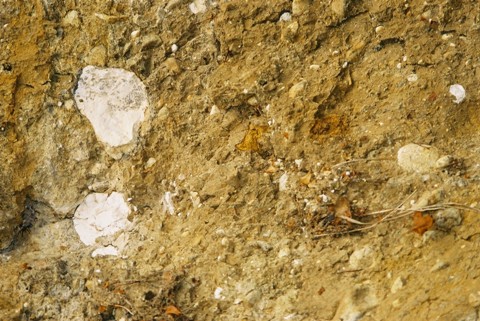
In a way, the old name describes it better at this location - it is literally a collection of every size of rock from boulders to clay. You can see the till within the sand pit from the western viewing platform. The sediment here is very poorly sorted with large pebbles and sand floating within a silty clay. When wet this clay is soft and sticky, but when dry it sets like concrete. When it was first laid down it would have been frozen at the base of a two kilometre thick sheet of ice. When such a massive amount of ice moves it tends to freeze to the ground it passes over and plucks up all kinds of rocks on its way. It then proceeds to grind the rocks by crushing them and splaying them out in a layer at the bottom of the ice. In this way a distinctive rock is formed that contains a whole range of sizes of particle. The following rocks can be found in the till:
Look at the attached identification sheet (Field sheet 1) to help with these rocks.The ice meltsWhen ice melts it often starts gradually and can build up into a torrential flow within a short space of time. This means that anything beneath and in front of the glacier can be caught up in the running water. Running water will sort the rocks and sand grains into their various sizes and will tend to drop them again in size order as the flow decreases again. If the waters are re-working till, then the rocks will be the same as seen in the till (described above and in the identification sheet). But which way did the water flow?
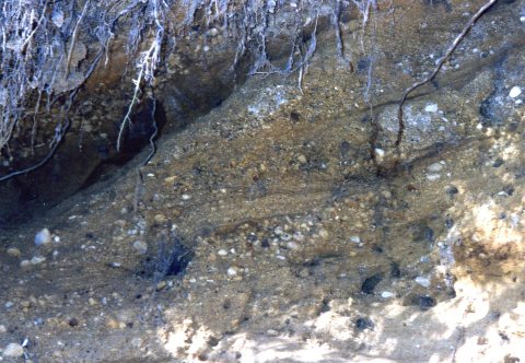
Which way did the waters flow?Current directions are easy for geologists to measure as long as they have certain clues. The two clues found here at Buckingham Sand Pit are:1. Aligned pebbles - pebbles are pushed over by flowing water so that the long axes point in the direction of flow (see Field Sheet 2) 2. Cross-stratification (inclined lines) - currents move pebbles and sand particles which begin to build up dunes and ripples under the water. The particles fall down the steep slope of the dune to form layers at the front edge. These can be seen today as 'lines' (image below). The lines point (are inclined down) in the direction of flow. If you measure this direction with a compass at Buckingham Sand Pit, then it indicates water flow was mostly to the north and NNW at this instant in Ice Age time, half a million years ago.
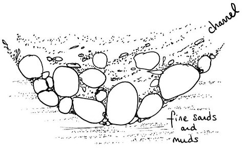
But what were these water currents - rivers, streams, other? In fact, the sands, gravels and boulders are very well confined to a sinuous ridge. The ridge represents a channel that was cut by the water into the bottom of the ice sheet, known as an esker. Eskers are well-known from Norfolk and Scotland , and although it is unfortunate that most of the sands have been quarried away some time ago, it would appear that these sediments form an esker. The water would have flowed like a river, but all the water and the sediment it carries is confined to the ice-bound cutting. Eventually these channels choke up with the sediment they carry.The climate warms upAs the climate warms, the ice begins to recede. Eventually, the ice is distant enough for the ground to be occasionally thawed, but the ground beneath the surface remains permanently frozen. This is known as tundra. It is possible for a specialised flora such as lichens, mosses and 'arctic-type' low level plants to thrive. The evidence for tundra can be seen from the eastern viewing platform in the form of contorted sediments and tiny plant fragments incorporated into organic-rich layers. Some of these contain charcoal and the interpretation and source of these fragments remains a mystery. Also, note the red layers which are also an indication of organic-rich pools of water on the surface. Organic material enhances the precipitation of iron oxides from these waters - hence the red colour.Activities for this site:
|

