|
Bucks Geology GroupKimmeridge Clay Formation
The Kimmeridge Clay Formation derives its name from Kimmeridge, in Dorset, where it forms spectacular grey shale cliffs for several miles either side of the village. It is the youngest in the series of Upper Jurassic Clay Formations, dating to around 152 million years ago.The Kimmeridge Clay crops out in an somewhat interrupted band from Dorset to Lincolnshire. Further northeast, beneath the North Sea, where it attains a huge thickness, it is the source for much of the North Sea Oil. The characteristics that make this formation a rich oil source are present in Buckinghamshire too - a high fossil organic component, although it has not been subjected to sufficient temperature to yield any hydrocarbon.
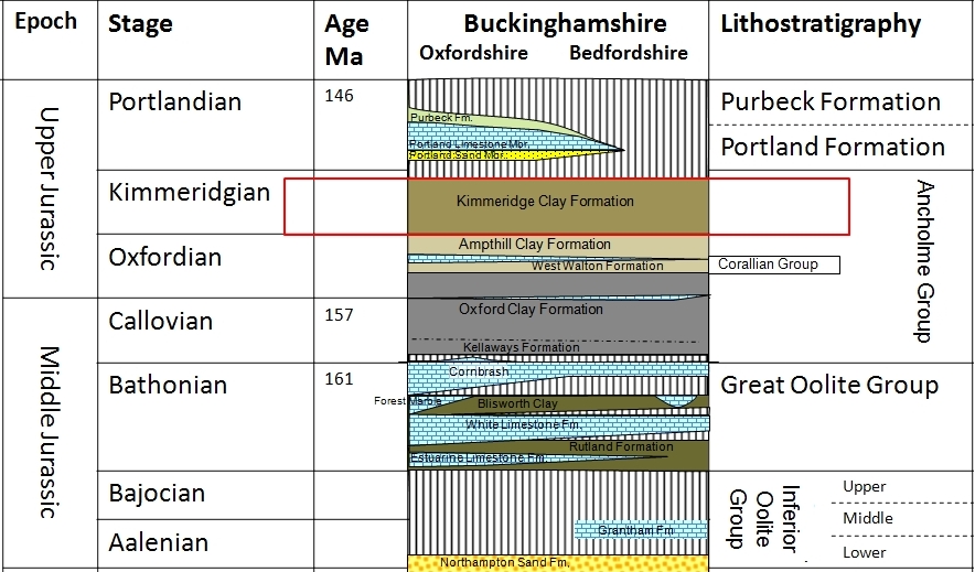
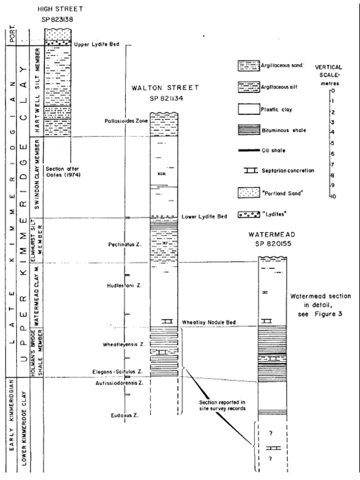
Diagram above: Stratigraphy of the Middle and Upper Jurassic in Buckinghamshire (Kimmeridge Clay Formation highlighted). The Formation is informally divisible into a lower and upper unit. The lower part is a uniform 15m thick across much of SE England, whereas the upper part is more variable, in part reflecting the effect of some tectonic activity (faulting and upwarping) during its deposition and also the removal of the upper parts during pre-Cretaceous erosion. The sequence at Aylesbury has been revealed in temporary exposures over recent decades, allowing the complete sequence to be determined. Cored boreholes at Hartwell and Brill, together with the M40 Motorway cutting, have confirmed that the Aylesbury section is reasonably representative of Buckinghamshire, although some changes occur towards the west. Comparison of Upper Kimmeridge Clay between Oxfordshire and the Wash reveals a gradual thickening ENE, along the outcrop, which is close to being parallel with the northern shoreline of the London Platform. The presence of intervals with more silt/sand and the non-deposition of some sections across the Oxford Shallows (which had been a positive feature since Middle Jurassic times, corroborate deposition in shallow water, where proximity to an eroding sandy source of sediment and sensitivity to small changes in sea-level would have the greatest effect on the stratigraphy. The Upper Kimmeridge Clay Formation was particularly well-exposed during the construction of the Watermead (Aylesbury) lake. Apart from the well-publicised discovery of associated giant Pliosaur bones, a detailed section was compiled and together with data from Walton Street (Aylesbury) enabled the Upper Kimmeridge Clay to be split into five members, from above, with thickness: 8.5m Hartwell Silt Member 7.5m Swindon Clay Member 4.0m Elmhurst Silt Member 6.0m Watermead Clay Member 5.0m Holman's Bridge Shale Member A conspicuous layer of large discoid calcareous concretions exists in the middle of the Holman's Bridge Shale, while another can be seen at the base of the Watermead Clay, which is much better developed in Oxfordshire where it has been called the "Wheatley Nodule Bed" (see these in the picture of Watermead, below).
The higher Kimmeridge Clay Stratigraphy in Aylesbury. Ref: Oates M.J. 1991.
Antique photographs courtesy of British Geological SurveyHover cursor over photograph for label.
Fossils from the Kimmeridge Clay Formation
The Lower Kimmeridge Clay free-swimming ammonites were predominantly part of a fauna that inhabited a more southerly ocean, and can be found in contemporary rocks in the Mediterranean. One brief episode of sea-deepening breached the barriers isolating the ammonite faunas to the northeast, allowing a sudden influx of northern species, which have been seen in a thin bed exposed in pipe-laying trenches near Hardwick. This event is traceable over all of Southern England and the North Sea.The base of the Upper Kimmeridge Clay is marked by the replacement of the earlier southern ammonite faunas with the later northern varieties. A series of photographs below illustrates these two populations of ammonites and also a number of reptile fossils. Hover your mouse over the small images to see a magnified image.
The Watermead pliosaur bones found were mainly ribs and the remains of massive vertebra. When laid out, these gave an estimated length of 25ft (7.5m) for the reptile. Unfortunately, no remains of the skull were found, which is a pity as this would have been 5ft (1.5m) in length with teeth up to 12 inches (30cm) long. The bones are today in the County Museum's store at Halton, with a few choice specimens on permanent display at the Museum in Aylesbury. 


Further reading suggestions: Oates M.J. (1991) Upper Kimmeridgian stratigraphy of Aylesbury, Buckinghamshire. Proc. Geol. Assoc. V.102. Part3. pg.185-199 pdf Images used with permission: © Copyright Buckinghamshire County Museum (Licence No. 44)
|


 Ichthyosaur vertebra. Ichthyosaur vertebra from the Kimmeridge Clay.
 Humerus of a large plesiosaurs - Cryptocleidus. Bucks County Museum. Specimen 1954.58.2
 Humerus or Femur of a Plesiosaur.
  Neck vertebra from a giant Pliosaur, from Watermead, Aylesbury.
  Aulocostephanus. Aulacostephanus was the endemic southern ocean ammonite, from the Lower Kimmeridge Clay
 Gravesia irius. Gravesia irius is rare, but common to both faunal realms and is therefore a valuable correlation tool.
 Pectinatites cornutifer, this ammonite characterises the Upper Kimmeridge Clay.Bucks County Museum Specimen No.1991.1.10
 Pectinatites (Virgatosphinctoides) decorosus, this ammonite characterised coarse ribbed ammonite of the Upper Kimmeridge Clay. Bucks County Museum Specimen No.1991.1.14
 Pectinatites woodwardi. Bucks County Museum Specimen No.1991.1.11
  Pectinatites wheatleyensis. Bucks County Museum Specimen No.1991.1.15.1
  hudlestoni") Pectinatites (Arkellites) hudlestoni. Bucks County Museum Specimen No.1991.1.12
Pectinatites (Arkellites) hudlestoni. Bucks County Museum Specimen No.1991.1.12") Pectinatites (Virgatosphinctoides). Bucks County Museum Specimen No.1991.1.7
Pectinatites (Virgatosphinctoides). Bucks County Museum Specimen No.1991.1.7 clavelli") Pectinatites (Virgatosphinctoides) clavelli. Bucks County Museum Specimen No.1991.1.5
Pectinatites (Virgatosphinctoides) clavelli. Bucks County Museum Specimen No.1991.1.5  Pavlovia. Pavlovia, also a northern form, has much coarser ribbing, like most late Kimmeridge Clay ammonites.
 Asteracanthus sp. sephalic spine Bucks County Museum Specimen No.1993.156.1
  Asteracanthus sp. Dorsal spine. Bucks County Museum Specimen No.1975.317.3
  Belemnites subquadratus (Roemer, 1836.) Bucks County Museum Specimen No.1957.150.1-3
 Belemnite phragmacone. The pragmocone is an internal part of the belemnites shell, it is conical and found at the front end of the gmain guard, generally only found in well preserved specimens. Bucks County Museum Specimen No.1923.362.1