|
Bucks Geology GroupWhat are Local Geological Sites (LGS)?Local Geological Sites (LGS) are regionally important geological and geomorphological sites which have been identified as being of great importance locally. Any site of national importance will be afforded protection under the SSSI system (Sites of Special Scientific Interest) which are administered by Natural England. Each County has a Geological Conservation group composed of volunteers with an interest in geology and who wish to enjoy and protect it. There are now more than 50 such groups across the UK with an association to the GeoConservation UK steering group.How is a site selected as a Local Geological Site (LGS)?When the Geo-Conservation group first set up in Buckinghamshire it was necessary to undertake a full survey of the County to assess what geology is present, what is visible and how much is in danger of being lost. The Buckinghamshire already has 9 geological SSSIs ( see details of these under the Conservation and SSSI tab), but Local Geological Sites (LGS) are selected in a different way to these, as they are of local or regional interest. Each Geo-Conservation group has an agreed selection criteria at a national level there is agreement on 4 criteria:
LGS Site selection criteria:Local Geological Sites (LGS) are sites that are considered worthy of protection for their Earth Science or landscape importance, but are not already protected as SSSIs. Sites are selected as satisfying one or more of the following criteria:
What level of protection do Local Geological Sites (LGS) have?Local Geological Sites (LGS), as their name suggests, are an equivalent to local Wildlife Sites and other non-statutory wildlife designations. Some Local Geological Sites (LGS) also coincide with local nature conservation sites. When the group identifies and agrees on a site being designated as a LGS it is submitted to the local authority and hence can be shown on 'alert maps'. In this way, the site will be taken into consideration through the planning system and the local planning authority.How does it work?Once a site is selected, the day-to-day conservation and management of sites depends upon agreements and cooperation with local landowners. The site information is logged with BMERC at the Bucks and Milton Keynes Environmental Records Centre, and the site is recorded on GIS map data and recommended for inclusion on the 'alert' lists of the local planning authority. The group continue to assess the site, managing it as appropriate, while also raising awareness of the general public to these sites and explaining why they are important. In order to do this the Bucks Earth Heritage Group provides information, education material, leaflets, books and leads field visits.Getting involvedThere are many opportunities to get involved with the activities of the group. Although expertise is needed in the process of selecting and interpreting sites, most of the group are members of the general public. The group needs people with an enjoyment of their local geology, and who want to know more. Sites are more than 'just geology' we need people who have expertise in wildlife or archaeology. We need people who can advise on conservation techniques, fencing, education, computers and IT - we need a treasurer - the list is endless! You can also just join to come and enjoy a walk or a talk.
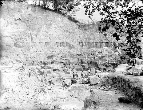
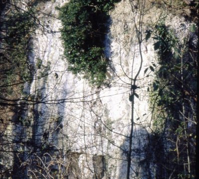
Medmenham Chalk Pit in 1920 and below the degraded face in 2006
The network of Buckinghamshire's Local Geological Sites (LGS), forms part of the nationwide network, and incorporates sites of educational, research, historical, or aesthetically importance. The network includes sites of importance to both professional and amateur geologists, as well as those sites amenable to and of interest to the general public. Buckinghamshire's Local Geological Sites (LGS) are divided into two local authority areas: Buckinghamshire and Milton KeynesBuckinghamshire: 27 sites
Milton Keynes: 7 sites
35 sites in total (as minuted 20-Feb-2026)
|