|
Bucks Earth Heritage GroupWhiteleaf Information SheetGeology
of Whiteleaf Hill, Princes Risborough - geological notes
Site
statistics
Grid reference:
SU 8215 0370. Ordnance Survey map: Aylesbury and Leighton Buzzard Sheet 165. Geological maps: 1:50
000 series Thame sheet 237; and Aylesbury sheet 238. Owned by:
Bucks County Council; managed by The Chilterns Countryside Management
Project. Area of site:
27 acres Access, location and parking: From the A4010 at Monks Risborough take the road signed ‘Whiteleaf’.
Park in the Whiteleaf Hill Car Park, next to the Ridgeway access point. This is
a large car park, suitable for groups using cars (coach access prohibited by low
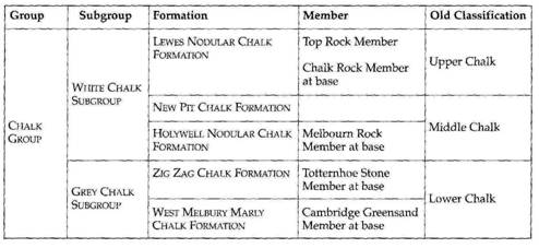
bar at entrance). Introduction * The terminology of ‘Lower, Middle and
Upper’ Chalk is now redundant, but appears in many maps and textbooks. The new
terminology is as follows:
Geology of the area Older rocks have been proved at depth by
boreholes. The oldest rocks penetrated by these boreholes are Cambrian to
Ordovician age marine mudstones. There are also The following Mesozoic era was dominated by
deposition under marine conditions, interspersed by regressions and substantial
periods of erosion. Directly overlaying the eroded Palaeozoic platform are
Jurassic sediments of the Lias. The Lias (Toarcian in age, c. 190
Ma) consists of limestones and muds deposited in a shallow, tropical sea which
deepened over time. Ammonites were prolific in this ocean. This strata does not
outcrop in the area of Whiteleaf, but can be seen in numerous small exposures in
north Bucks. Overlying the Lias, also not seen at outcrop in the area, but lying
some 400 m beneath Whiteleaf is the Great Oolite (Bathonian to earliest
Callovian in age c. 170 Ma). This is a collective name for a number of
beds of limestones and clays, predominantly known for its oolitic limestones
which outcrop to the west of Whiteleaf in the The following sequence from 170 to 150 Ma is to
be found at outcrop in the Vale of Aylesbury lying beneath Whiteleaf. However,
exposures are rare and often temporary. The sequence of the Cornbrash to
the Kellaways Beds and Oxford Clay to Ampthill and Kimmeridge
Clays represents deepening seas. The evidence for this is seen in the rubbly,
wave-torn Cornbrash limestones (shallow marine) to the progressively offshore
muds of the Also visible from the viewpoint is the
topographic expression (the hills of the mid-vale) of the harder beds which make
up the next part of the geological succession: the The Whitchurch Sandstone is best seen in
the buildings and walls of Brill, although it commonly occurs as building blocks
in other villages in the area. It is distinctive due to its red-brown colour,
but should not be confused with the iron-cemented Lower Greensand (outcropping
at Brickhill), but also sometimes used in buildings within the vale. This period
of time is an enigmatic one for Bucks. The Whitchurch Sands are our only
evidence of large rivers which criss-crossed an uplifted landscape. The evidence
for the Bucks environment of the end-Jurassic and early Cretaceous is missing,
as 40 million years of history are eroded away during this time. The following
period (the Lower Cretaceous, c. 115 Ma) is represented sparsely by the Lower
Greensand locally. These sands and occasional sandstone deposits outcrop
as the Greensand Ridge in the Brickhill area, but form no exposures in the area
of Whiteleaf. There are small outcrops present at Aston Sandford, Ford and
Bishopstone which are composed of a coarse, iron-stained, pebbly sand. However,
the lithology can only be inferred by a subtle change in soil, not by exposures.
The Lower Greensand represents a period when the sea returned to the area, which
broke through as a narrow seaway from The Gault forms the low ground immediately
adjacent to the Whiteleaf escarpment, from Longwick to Aston Stanford, and
forming a belt 5 km in width parallel to the escarpment. There are a few
outliers of Gault, notably at Chilton and Long Crendon, where the Gault Clays
cap the top of the hills. The break in slope at Monks Risborough (from c.
90 m to 100-110 m) is entirely due to the Upper Greensand outcrop
overlying the Gault. This rock is the shoreline equivalent of the Gault – and
is composed of a calcareous sandstone and siltstone. The Upper Greensand is
harder and therefore produces a topographic ‘bump’, a ledge which follows
the contours of the land surface the far side of the towns of Monks and Princes
Risborough (away from the escarpment). There is also a line of springs at this
level (the water penetrates the porous sandstone, but the impermeable clays of
the Gault beneath prevents further draining downwards towards the water table.
The water thus appears at the surface as a spring line marking this junction. The majority of Monks Risborough and Princes
Risborough lies on the pale grey, chalky clays of the Lower Chalk. The
ground surface begins to rise gently across the Lower Chalk outcrop from just
over 100 m to c. 120 m. The Melbourne Rock is a hard bed which
forms another notable ledge on the topography at the foot of the escarpment and
marks the boundary of Lower and Middle Chalk and lies in the
fields beneath – just before the housing areas of the town. There is a second
line of springs at this junction - marking the more porous Melbourne Rock with
the clay-rich and more impermeable Lower Chalk. The The steepest incline of the Chalk escarpment,
which rapidly increases to c. 200 m, is formed by the Middle Chalk. The
uppermost 10 m of the Middle Chalk is visible in the bare parts of the slopes at
Whiteleaf below the Whiteleaf Cross (SP 822 040). This uppermost section can be
seen to contain some flints (but not as numerous as the Upper Chalk). The Chalk Rock has been a common building
stone in the past (often called ‘Clunch’ by the Victorians) and is a harder
bed marking the boundary between the Middle and Upper Chalk. This can be seen in the small quarry exposure close to
the road. The Chalk Rock is a hardground which often contains numerous Thalassinoides
burrows and represents several periods of breaks in sedimentation of the normal
Chalk lithology. Both the Middle and Upper Chalk are
well-cemented, pure white limestones. The differences lie in the thin and
occasional marl bands in the Middle Chalk and the distinctive bands of flint
within the well-bedded Upper Chalk. The Middle Chalk can be best seen in the
small quarry reached from a pathway running from the Whiteleaf car park
(adjacent to the road). The Upper Chalk makes up the remaining 50 m of the
topmost escarpment slope along parts of this hillside. At the end of the Mesozoic period further earth
movements (the Laramide) again resulted in this area becoming a landmass. During
this period there was no doubt the deposition of Palaeogene sediments which are
seen in adjacent areas (e.g. the palaeosols of the Reading Beds at Chesham to
the east of Whiteleaf, or to the south at Denham and The deposit lying directly on the topmost Chalk
is Clay-with-flints. This is a residual deposit formed from deep
weathering of the Chalk. The Clay-with-flints has a patchy distribution which
follows the topmost escarpment and dip-slope, but it is dissected and removed
along numerous dry valleys. Clay-with-flints is usually a reddish-brown clay
containing lots of angular flints (up to 50% flints). Sometimes it is a yellow
clay or a reddish-brown clayey sand. Whatever its overall appearance it is a
Chalk solution residue which is often added to by illuvial clay from the
overlying Tertiary or Quaternary deposits. The dry valley systems were cut during the Ice
Age. Although these valleys are dry today, they were once the site of torrential
flow from melt waters of a retreating ice sheet and melting snow. They are
common features throughout the Chalk escarpments of southern There are also deposits within dry valleys, for
instance, the Princes Risborough Sand and Gravel, which were deposited by
a southeasterly flowing river - an ancestral River Wye (after the dry valleys
were cut). This river ceased to flow when the tributaries leading to the
ancestral Thame developed and created a different drainage system. The deposit
is rich in chalk and flint pebbles and lies in a very restricted area on the
escarpment known as the Princes Risborough Gap. This deposit (and others like it
at the bottom of dry valleys) comprises sands and gravels that are rich in chalk
and flint. At the surface this deposit is always decalcified to form a
reddish-brown, sandy loam with abundant flint pebbles (angular and rounded). Till
is found to the northwest of Aylesbury and proves that the Anglian ice sheet
extended to, and beyond, the Chilterns. It consists of a brown, pebbly clay
where the pebbles are both local (mainly flints, small Chalk pebbles and
reworked Kimmeridge clay) as well as from further afield (quartzite and
‘Bunter’ quartz pebbles). The area of peat present southeast of
Longwick is due to the waterlogged ground forming as a result of spring seepage
from the base of the Upper Greensand. This is the line that a number of small
springs occur along the base of the escarpment at Whiteleaf. These are a direct
result of water catchment through the permeable Chalk and Upper Greensand. The
water passes downwards until it reaches the impermeable clays of the Gault and
will then run along the top surface of the Gault to emerge at a spring line.
|